
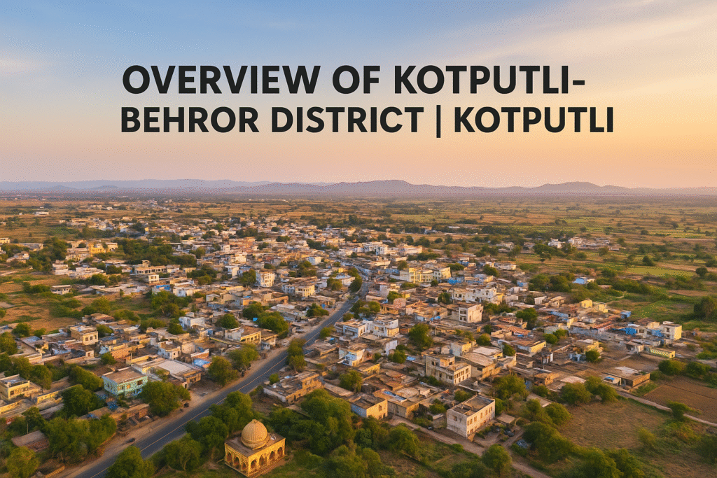
Overview of Kotputli Behror District
 Kotputli-Behror district is a district in the state of Rajasthan. It was officially formed on 7 August 2023 after being carved out from parts of Jaipur and Alwar districts. located in the north eastern part of Rajasthan. The District is one of Rajasthan’s newest administrative divisions, officially formed in 2023. The district consists of multiple tehsils, such as Kotputli, Behror, Neemrana, Bansur, Mandhan, Paota, Viratnagar, and Narayanpur, with Kotputli and Behror acting together as the district headquarters.
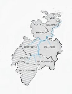
The Bhabru rock edicts found here reference Piyadasi, a name associated with Emperor Ashoka, highlighting the area’s ancient heritage. A significant portion of the district includes the Tehsils of Behror, Neemrana, Bansur, and Mandhan, collectively known as the Rath Region, however, Mundawar Tehsil, which also belonged to this region, now falls under the newly established Khairthal District.
 Kotputli is a city and municipal council in the Kotputli-Behror district of Rajasthan, located between Jaipur and New Delhi. Serving as the district headquarters, it holds cultural significance as part of the Matsya-Bairath region.
The city is known for its historic temples and old institutions like Sardar School and Sardar Zanana Hospital, established with support from the Morijawala and Tijoriwala families. Over the years, Kotputli has developed with new schools, hospitals, and infrastructure, blending heritage with modern progress.
| Kotputli–Behror District (Rajasthan, India) | |
|---|---|
| Country | 🇮🇳 India |
| State | Rajasthan |
| Division | Jaipur |
| District Headquarters | Kotputli, Behror |
| Tehsils | Kotputli, Behror, Bansur, Neemrana, Paota, Viratnagar, Mandhan, Narayanpur |
| Government | District Magistrate: Priyanka Goswami (IAS) |
| Time Zone | UTC+5:30 (Indian Standard Time – IST) |
| PIN Codes | 30310X, 30170X, 303108 |
| Telephone Code | 01421 |
| Vehicle Registration | RJ-32 |
| Major Highways | National Highway 48 (NH-48), National Highway 148B (NH-148B) |
| Population (2011) | 49,202 (Kotputli town) |
| Official Language | Hindi |
| Website | Official website |
The district is often referred to as Vip Jila Kotputli, symbolizing its growth, cultural significance, and modernization. Kotputli serves as the heart of this district, combining historical heritage with emerging infrastructure projects.
Industries like cement manufacturing, logistics hubs, agriculture, and small-scale manufacturing form the backbone of the local economy. The district is also experiencing rapid urbanization and infrastructure development, making it a focus of regional planning.
Vip Kotputli regularly provides the latest news, updates, and insights about Kotputli-Behror District, helping residents, visitors, and investors stay informed.
History of Kotputli
Ancient Period
 Archaeological excavations in and around the Sahibi River basin have revealed evidence from the late Harappan period, showing that this region was inhabited thousands of years ago. Kotputli lies within the wider Matsya Cultural Zone, which played an important role in early Indian civilization.
The nearby town of Viratnagar is mentioned in ancient Indian texts as the capital of the Matsya Kingdom, believed to have been founded by King Kirata. It is also said to be the place where the Pandavas spent their final year of exile in disguise. Remarkably, one of the oldest known Buddhist shrines with a circular design has been discovered here.
During the Mauryan Empire, this area was under the rule of Emperor Ashoka. His name, “Piyadasi,” appears in the Bhabru Rock Edicts, where he identifies himself as “Piyadasi, Raja Magadhe” (King of Magadha). Numerous Indo-Greek coins have also been unearthed near Viratnagar, suggesting it was once a prosperous trade hub influenced by Indo-Greek rulers.
Medieval Era
 In 1009 AD, the Narayanpur region was attacked by Mahmud of Ghazni, leading to widespread destruction of temples and settlements. The town was later rebuilt in a new location, which is now the headquarters of Narayanpur Tehsil.
During the medieval period, the Tomars and Chauhans emerged as major powers in the region. The northern parts of present-day Kotputli district were ruled by the Bhadanka Empire, which was eventually defeated by Prithviraj Chauhan around 1150 AD. After his loss in the Battle of Tarain (1192 AD), the area came under the control of the Delhi Sultanate, and was governed as part of the Narnaul Suba.
In later years, Rao Madan Singh (Rao Made Chauhan) founded Madanpur, now known as Mundawar, while his descendants expanded control over Barod and Neemrana. Despite internal conflicts and resistance to forced conversions during the Sultanate period, the Chauhans maintained influence in parts of the region.
The Shekhawats later expanded into Bansur and nearby areas, establishing several estates including Khetri, Sikar, and Shahpura. Following the decline of Mughal authority, regional chieftains and powers such as the Marathas and Bharatpur rulers contested control. Eventually, Pratap Singh of the Naruka family captured the Alwar Fort in 1775, forming the Alwar Princely State, which included most parts of today’s Kotputli-Behror region.
Colonial Period
Before British rule, Kotputli was governed by a succession of rulers — Sultans, Mughals, Marathas, and later the Alwar Princely State. The Kotputli Tehsil was under the Khetri State during this period.
One of the most tragic and defining events in local history was the Neemuchana Massacre (1925), often referred to as the “Jallianwala Bagh of Rajasthan.” When landlords in Bansur revolted against heavy taxation imposed by the Alwar ruler, the state and British forces jointly suppressed the movement with extreme brutality. On 14 May 1925, troops surrounded Neemuchana village and opened fire without warning, killing over 150 farmers (official count) — with some reports suggesting more than 1,500 deaths.
Mahatma Gandhi condemned the incident, calling it “more vicious than the Jallianwala Bagh tragedy.” The outrage eventually forced the Alwar government to withdraw its decision and pay compensation to the victims’ families.
Modern Era and District Formation
After India’s independence in 1947, Kotputli became part of the Alwar State, and later merged into the State of Rajasthan. Due to the region’s distance from Alwar’s headquarters (about 100 km from Kotputli, 80 km from Neemrana, and 60 km from Behror), locals long demanded a separate administrative district.
In the 2023 Rajasthan Budget, the government officially created 19 new districts, one of which was the Kotputli-Behror (Rath) District, fulfilling a long-standing public demand and recognizing the area’s unique historical and cultural identity.
 Behror, being a part of Alwar, has a rich history as a trade and cultural center. Both Kotputli and Behror have forts, temples, and stepwells that reflect Rajasthan’s architectural and historical legacy.
The creation of Kotputli-Behror District in 2023 aimed to improve governance, administrative efficiency, and public services. The new district was locally promoted as Vip Jila Kotputli, representing both the preservation of heritage and the district’s forward-looking development.
Geography of Kotputli-Behror District
Topography
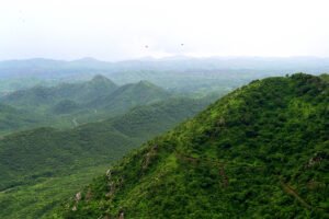
Kotputli-Behror district lies on the northernmost fringe of the Aravalli Range, making it a region of mixed geography — fertile plains interspersed with rugged hillocks. The Sahibi River flows through the district, enriching the plains and sustaining agriculture.
The Aravalli Hills form natural boundaries on three sides of the district, making it geographically distinct from much of Rajasthan. Only the northern side opens out towards Delhi, where the plains become broader and more populated.
To the south, the Aravalli hillocks mark the boundary with Shahpura in Jaipur district, while a series of parallel limestone and sandstone ridges separates Bansur Tehsil from Alwar district.
Toward the southeast, the Sariska Tiger Reserve lies beyond these limestone chains.
In the northwest, the spread of the Thar Desert is effectively checked by the Aravalli ranges, preventing desertification of the fertile plains.
Despite its natural beauty, the region faces severe water scarcity. The degradation of Aravalli catchment areas, overextraction of groundwater, and reduced surface water sources have led to growing water stress across the district.
Climate
The climate of Kotputli-Behror is mostly dry and semi-arid, with rainfall concentrated between September and October.
Summers are long, hot, and dry, often accompanied by scorching winds locally known as ‘lu’.
Winters are comparatively cold, with temperatures occasionally dropping close to the freezing point.
Rivers and Dams
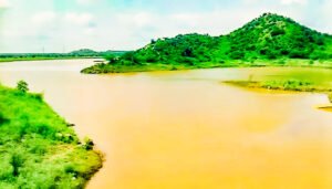
The Sahibi (or Sabi) River is the main river of the district. Originating from the Aravalli Hills along the border with Sikar and Jaipur districts, it is an ephemeral, rain-fed river stretching about 300 km before merging into the Yamuna River near Delhi.
 There are no major natural lakes, but several small dams and bunds play a role in irrigation and water storage:
-
Buchara Dam on the Sota River near Paota
-
Babariya Bund in Bansur Tehsil
Other important tributaries and drainage nalas include:
-
Sota River – a major tributary that joins the Sahibi near Sotanala (Behror Tehsil)
-
Narayanpur Nala – drains northwest Bansur Tehsil and flows into the Sahibi
-
Surakh Nala – from Babariya Bund in Bansur, merges with the Sahibi at Sodawas Hajipur
-
Harsora Nala – from Bansur, meets the Sahibi at Bijwar in Mundawar Tehsil (Khairthal District)
-
Ajabgarh Nala (Kali Nadi) and Partabgarh Nala – originate in Bansur and Thanagazi, joining together to form the Banganga Stream near Baldeogarh (Jaipur District)
These drainage systems demonstrate the district’s complex hydrological network dependent largely on monsoon rainfall.
Springs
The district also contains a few natural springs, the most notable being a hot water spring at Talvriksh near Bansur Tehsil. Several cold-water springs are also found scattered across the hilly terrain.
Flora and Fauna
The vegetation is dry deciduous, dominated by trees such as Neem, Dhak (Flame of the Forest), Kikar (Acacia), and Khejri. Along the riverbanks of the Sahibi and Sota rivers, lemongrass grows abundantly.
Common wild animals include Nilgai (Blue Bull), Leopard, Tiger, Jackal, and Hyena, reflecting the district’s proximity to Sariska Tiger Reserve.
Mineral Resources
 Kotputli-Behror district is rich in mineral deposits, especially quartz and granite. These resources, however, are primarily located within the ecologically sensitive Aravalli ranges, where mining activities are carefully regulated to prevent environmental degradation.
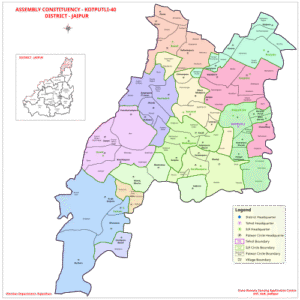
Administration and Demographics of Kotputi
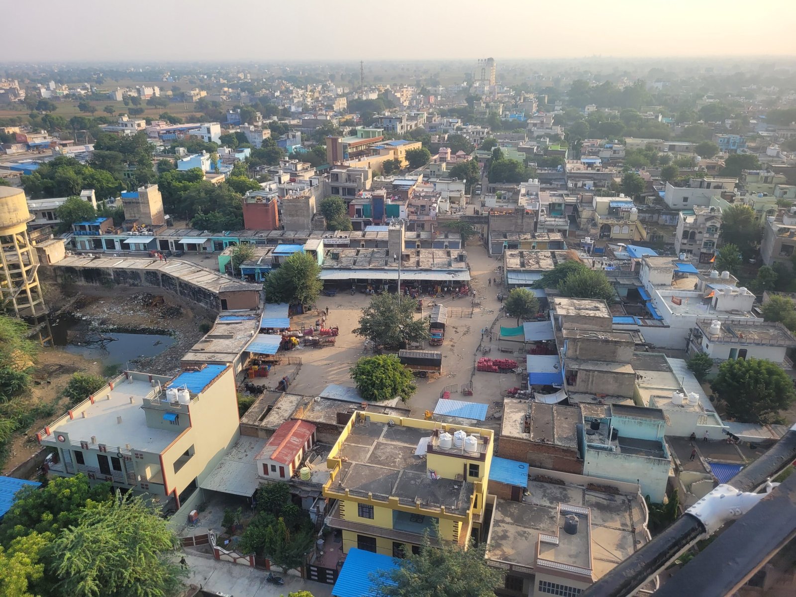
Kotputli is a municipality within the newly formed Kotputli-Behror district of Rajasthan, administered by a municipality divided into 30 wards. As of the 2011 Census, the city’s population was 49,202, with a male to female ratio of approximately 889 and a literacy rate of 80.5%. Hinduism is the dominant religion, and the city includes both urban and rural populations, with a significant portion of the population being children under six years of age.
The Kotputli-Behror District consists of three main tehsils: Kotputli, Behror, and Shahpura. Kotputli town serves as the district headquarters, housing administrative offices, government departments, and law courts.
Rural governance is managed through Gram Panchayats, which handle local infrastructure, water, and public services. The formation of this district has brought administration closer to citizens, ensuring better delivery of services.
Administration of Kotputli
District: Kotputli-Behror district (newly formed in 2023 from parts of Jaipur and Alwar districts).
Tehsil: Kotputli tehsil.
PIN: 303108
Municipality: Kotputli is a municipality within the tehsil and is divided into 30 wards for which elections are held every five years.
District Headquarters: Jointly located at Behror and Kotputli
Telephone code: 01421
Vehicle registration: RJ 32
Demographics of Kotputli (as of 2011 Census)
- Total Population: 49,202
- Male Population: 26,051
- Female Population: 23,151
- Sex Ratio: 889 (females per 1,000 males)
- Urban/Rural: 88.1% urban, 11.9% rural
- Population Aged 0-6: 6,770 (14% of total population)
- Child Sex Ratio (0-6 years): 821 (children per 1,000 males)
- Literacy Rate: 80.5% (higher than the district average of 75.5%)
- Male Literacy Rate: 90.34%
- Female Literacy Rate: 69.49%
- Religion: 97.6% Hindu, 2.0% Muslim, with a small percentage of Christians, Sikhs, and Jains
- Caste: Scheduled Caste (SC) constitutes 9.93% and Scheduled Tribe (ST) is 5.95%
- Population: Approximately 1.6 million
- Languages: Hindi (official), Rajasthani, Haryanvi (in border areas)
- Religion: Predominantly Hindu, with Muslim, Sikh, and Jain minorities
- Culture: Folk music, dance, and colorful festivals are prominent in daily life
Economy and Industries of Kotputli Behror District
Kotputli-Behror District has a diverse economy combining agriculture, industry, and trade.
Economy
Agriculture forms the backbone of the district’s economy, contributing the major share to its Gross Domestic Product (GDP), followed by the industrial and manufacturing sectors.
Industry
Due to its strategic location between the national and state capitals and its excellent connectivity via NH-48 (Delhi–Jaipur Highway), the district has emerged as a major industrial hub in northern Rajasthan.
Several RIICO industrial areas have been developed by the government, including:
Neemrana RIICO, Neemrana Japanese SEZ, Behror RIICO, Shahjahanpur RIICO, Sotanala RIICO, and Keshwana RIICO.
-
Behror RIICO is the oldest industrial and manufacturing cluster of the district.
-
The Neemrana Japanese Zone and Export Promotion Industrial Park (EPIP) contribute the most to the district’s industrial GDP.
-
Neemrana hosts over 1,500 small and large industries, including major brands such as Daikin, Havells, Hero MotoCorp, Parle-G, and Richlite Biscuits.
-
Behror is home to Greenlam Plywood, a major manufacturing unit, while Keshwana houses Barmalt, a well-known malt producer.
-
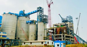
Kotputli features the large UltraTech Cement Plant of the Aditya Birla Group, a key contributor to Rajasthan’s cement output.
 According to the Census of India 2011, the most important manufactured commodities across major towns were:
| Town/City | Major Products (2011) |
|---|---|
| Behror | Cement, Granite Tiles, Sunmica |
| Neemrana | Cotton Yarn, Electric Wire |
| Shahjahanpur | Wooden Furniture, Textiles, Mustard Oil |
| Kotputli | Vanaspati Ghee, Mustard Oil, Grain Products |
| Viratnagar | Leather Shoes (Mojaris) |
(Note: Industrial composition has diversified significantly in recent years.)
Black Marble – Bhainslana
The Bhainslana Marble, a premium variety of black marble mined in Bhainslana village, is a key mineral resource of the district.
It gained national prominence for being used in the new Indian Parliament building and is also widely used in sculpting idols and architectural designs.
Agriculture
The Behror–Neemrana region leads in the cultivation of mustard and wheat, while cotton is another significant crop.
Agricultural trade is supported by major mandis (grain markets) located in Kotputli and Behror.
Livestock – Jakhrana Goat
The Jakhrana goat, native to Jakhrana village near Behror (close to the Haryana border), is one of India’s most productive milch goat breeds.
It is known for its high milk yield and adaptability, making it valuable for both dairy and breeding purposes.
Satellite & Geographic Context
An ISS night photograph of the district highlights the brightly lit industrial belt along NH-48, marking the concentration of factories around Behror and Neemrana.
The plains of Kotputli–Behror, seen clearly from satellite imagery, demonstrate the contrast between the industrial corridor and the surrounding agricultural lands.
Agriculture: Mustard, wheat, bajra, and seasonal vegetables
Logistics & Warehousing: Boosted by NH-48 and proximity to Delhi
Small-scale industries: Local crafts, dairy, and manufacturing units
The district is attracting investors and entrepreneurs due to its industrial potential and strategic location. Vip Kotputli helps promote these business opportunities and supports local economic growth.
Culture and Festivals
Kotputli-Behror has a rich cultural heritage, reflecting Rajasthan’s traditional lifestyle:
- Major Festivals: Gangaur, Teej, Holi, Diwali, Kotputli Mela
- Folk Arts: Kalbeliya dance, Ghoomar, Mand singing
- Crafts: Traditional textiles, jewelry, pottery, and local handicrafts
These cultural practices not only preserve the region’s history but also attract tourists and promote community participation.
Tourism and Heritage Sites
Kotputli-Behror District offers several tourism attractions:
| Places of Interest – Kotputli-Behror District | |
|---|---|
| Viratnagar Stupas | Located on Bijak Ki Pahari, these Buddhist complexes date to the 3rd century BCE. Built during Ashoka’s reign, they include the Bairat and Calcutta-Bairat Rock Edicts — the earliest circular Buddhist shrine in India. |
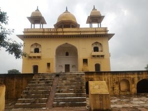
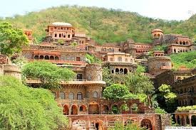
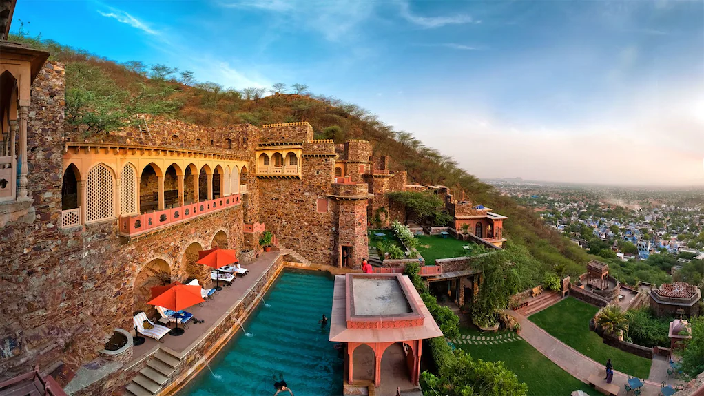
| Neemrana Fort | Built in the 16th century, this iconic fort in Neemrana Tehsil was ruled by the Chauhans (descendants of Prithviraj Chauhan) until 1947. It is now a major heritage hotel and tourist destination. |
| Neemrana Baori (Stepwell) | A nine-storey-deep stepwell with 170 steps and 86 arched openings, built by Raja Todarmal. Each level is about 20 ft high and leads to a deep underground water pool. |
| Bansur Fort | Situated on a small hillock in Bansur town, this multi-angular fort (16th–17th century) served as a strategic border post between Jaipur and Bharatpur States. |
| Taseeng Fort | Located 5 km from Behror in the Aravallis, once ruled by the Bad Gurjar clan and earlier by Chauhans of Machedi. Now in ruins due to neglect. |
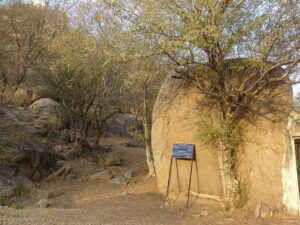
| Bhabru Rock Edicts | Minor Rock Edicts of Emperor Ashoka found near Bhabru Hills. Discovered 1840 by Captain Burt; inscription refers to Ashoka as “Piyadasi Raja Magadhe”. |
| Buchara Dam | Built in 1889 on the Sota River (tributary of Sahibi) by the King of Jaipur. The dam has a 35 ft embankment and supports local irrigation. |
| Mansa Mata Temple | 637-year-old temple in Dahmi dedicated to Goddess Mansa Devi; attracts large crowds during Navratri. |
| Baba Khetanath Temple | Located in Joshihera, Neemrana, this temple and ashram complex is a major spiritual center of the region. |
| Saroond Mata Temple | Ancient Devi temple atop a hill on the banks of Sota River in Saroond village along the Kotputli–Neem Ka Thana Highway. |
| Hanuman Temple, Rundh Bardod | Located near Barrod (Behror Tehsil), this temple lies within a sacred grove and is a local pilgrimage spot. |
| RTDC Midway Behror | A landmark hotel on NH-8 (midway Delhi–Jaipur) run by Rajasthan Tourism. PM Atal Bihari Vajpayee celebrated his 79th birthday here. |
| Hajipur Fort | Built under Mughal Emperor Akbar to protect trade convoys to Alwar from bandit attacks. Located in Bansur Tehsil. |
| Bardod Rundh Palace | Former royal hunting lodge of the Alwar princely state, situated in Bardod Rundh. |
| Rundhs of Kotputli–Behror | Reserve forests used for royal hunting and grazing under Alwar State. Many now face encroachments. “Banis” were smaller community forests. |
| Buchara Sanctuary | Declared a Leopard Sanctuary in 2023, spanning about 50 km² across Kotputli and Paota Tehsils. |
| Rath Cattle Fair, Behror | Annual fair in May to promote the Rath cattle breed. Attracts farmers and visitors from across the region. |
Vip Kotputli (https://vipkotputli.com) promotes these sites and provides visitors with latest news and updates about events, cultural programs, and tourist facilities in Vip Jila Kotputli.
Education and Infrastructure
The district has developed significantly in education and infrastructure:
Educational Institutions: Government College Kotputli, Behror Engineering College, Kendriya Vidyalaya Kotputli
Healthcare Facilities: CHC Kotputli, Government Hospital Behror, private clinics
Infrastructure: Modern highways, reliable electricity, water supply, and internet connectivity
The government and local initiatives are ensuring that Kotputli-Behror becomes a well-planned district with modern facilities while retaining its traditional charm.
Modern Development Projects
Several projects are transforming Kotputli-Behror District:
Delhi-Mumbai Expressway: Enhances connectivity and trade
Dedicated Freight Corridor (DFC): Boosts logistics and industrial growth
RIICO Industrial Expansion: Supports manufacturing and warehouses
Renewable Energy Projects: Promotes sustainable development
Vip Kotputli provides regular updates on these projects, helping residents, businesses, and investors stay informed.
Latest News & Updates by Vip Kotputli
Vip Kotputli is the primary platform for:
Local news and district updates
Government announcements and development plans
Community events and festivals
Business opportunities and industrial growth
Tourism updates and cultural programs
Visit Vip Kotputli for daily news, updates, and insights about Kotputli-Behror District, also called Vip Jila Kotputli. For more latest Kotputli News and local updates, visit vipkotputli.com or
Kotputli News Contact Number: +91 8696398646
Kotputli News WhatsApp Number: +91 8696398646
FAQs
1. Where is Kotputli-Behror District located?
- Kotputli-Behror District is located in northeastern Rajasthan, connecting Jaipur and Delhi, with proximity to Alwar, Sikar, and Rewari districts.
2. When was Kotputli-Behror District formed?
- The district was officially formed in 2023 as part of Rajasthan’s administrative reorganization.
3. What is “Vip Jila Kotputli”?
- “Vip Jila Kotputli” is a local name representing Kotputli-Behror District, highlighting its cultural significance, rapid development, and modernization.
4. What is the district headquarters of Kotputli-Behror?
- The district headquarters are jointly located at Behror and Kotputli.
5. What is the PIN code of Kotputli?
- The PIN code of Kotputli is 303108.
6. What industries are prominent in Kotputli-Behror District?
- Major industries include cement manufacturing (UltraTech, Wonder Cement, Shree Cement), agriculture (wheat, mustard, bajra), logistics, and small-scale manufacturing.
7. What is the climate like in Kotputli-Behror District?
- The climate is semi-arid, with hot summers (April to June) and mild winters (November to February).
8. What languages are spoken in Kotputli-Behror District?
- The primary language spoken is Hindi, with significant use of the Bangru dialect. Other local languages include Rajasthani and Haryanvi, especially in border areas.
9. What are some major cultural festivals in Kotputli-Behror?
- Major festivals include Gangaur, Teej, Holi, Diwali, and the Kotputli Mela.
10. What are the main tourist attractions in Kotputli-Behror?
- Key attractions include Kotputli Fort, Behror Fort, Shahpura Temples, Sotanala Hills, and the Aravalli Trails for nature tourism.
11. What is the population of Kotputli as per the 2011 Census?
- Kotputli had a population of 49,202, with a literacy rate of 80.5%.
12. What is the sex ratio in Kotputli?
- The sex ratio in Kotputli is 889 females per 1,000 males.
13. What is the child sex ratio in Kotputli?
- The child sex ratio (0-6 years) in Kotputli is 821 females per 1,000 males.
14. What educational institutions are available in Kotputli-Behror?
- Notable educational institutions include Government College Kotputli, Behror Engineering College, and Kendriya Vidyalaya Kotputli.
15. What are the main rivers in Kotputli-Behror District?
- The main rivers are the Sahibi and Sota, which are seasonal but important for agriculture.
16. What is the vehicle registration code for Kotputli?
- The vehicle registration code for Kotputli is RJ 32.
17. What industries are emerging in Kotputli-Behror District due to its strategic location?
- Emerging industries include logistics and warehousing, driven by Kotputli’s location on NH-48, as well as small-scale manufacturing and real estate growth due to the district’s increasing infrastructure development.
18. What is the literacy rate in Kotputli compared to the district average?
- The literacy rate in Kotputli is 80.5%, higher than the district average of 75.5%.
19. What is the population density of Kotputli?
- As of the 2011 Census, Kotputli had a population density of around 1,271 people per square kilometer.
20. What are the primary crops grown in Kotputli-Behror District?
- The main crops include wheat, mustard, bajra, and various seasonal vegetables, forming the backbone of the district’s rural economy.
21. What are the key tourist activities in Kotputli-Behror?
- Tourists can enjoy exploring historical forts, trekking in the Sotanala Hills, and nature tourism along the Aravalli trails, as well as visiting ancient temples and local handicraft markets.
22. What is the role of Gram Panchayats in Kotputli-Behror District?
- Gram Panchayats manage local governance, including infrastructure development, water supply, and public services in rural areas.
23. What is the role of the RIICO in the district’s development?
- Rajasthan State Industrial Development and Investment Corporation (RIICO) is playing a key role in expanding industrial infrastructure in the district, supporting manufacturing and warehousing sectors.
24. How does Kotputli’s location benefit its economy?
- Kotputli’s strategic location along NH-48 connects it to major cities like Jaipur and Delhi, enhancing trade, logistics, and industrial opportunities.
25. What is the significance of Kotputli in Rajasthan’s history?
- Kotputli historically served as an important trade and military post for the Kachwaha Rajputs, located on the Delhi-Ajmer trade route.
26. What are the key tourist spots in Behror?
- Behror Fort, a heritage site that is now a cultural hotel, is one of the top tourist attractions in Behror, along with its nearby temples and historical landmarks.
27. What are the major transportation options available in Kotputli-Behror?
- The district is well-connected by road (NH-48), with buses and private vehicles providing access to nearby cities. The nearest railway station is in Kotputli, connecting it to larger hubs like Jaipur and Delhi.
28. How are educational standards improving in Kotputli-Behror District?
- The district is witnessing an increase in the number of educational institutions, such as the Government College Kotputli and Behror Engineering College, as well as a focus on improving literacy rates.
29. What are the predominant religions practiced in Kotputli-Behror District?
- The majority of the population follows Hinduism, but there are also small communities of Muslims, Sikhs, Jains, and Christians.
30. What is the role of the Vip Kotputli platform in the district?
- Vip Kotputli serves as a crucial local platform providing residents with updates on government schemes, local news, cultural events, tourism, business opportunities, and other district developments.
Conclusion
Kotputli-Behror District, also known as Vip Jila Kotputli, is emerging as a cultural, industrial, and administrative hub in Rajasthan. With its strategic location, historical forts, scenic landscapes, and growing infrastructure, Kotputli is becoming the heart of the district.

Pingback: कोटपूतली–किशनगढ़ एक्सप्रेस वे के लिए 14 गांवों में भूमि उपयोग परिवर्तन व विकास कार्यों पर रोक